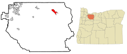
Mount Hood Village, Oregon | |
|---|---|
 | |
| Coordinates: 45°22′42″N 121°53′12″W / 45.37833°N 121.88667°W | |
| Country | United States |
| State | Oregon |
| County | Clackamas |
| Area | |
• Total | 26.1 sq mi (67.7 km2) |
| • Land | 26.1 sq mi (67.7 km2) |
| • Water | 0.0 sq mi (0.0 km2) |
| Elevation | 1,506 ft (459 m) |
| Population (2010) | |
• Total | 4,864 |
| • Density | 186/sq mi (71.8/km2) |
| Time zone | UTC-8 (Pacific (PST)) |
| • Summer (DST) | UTC-7 (PDT) |
| ZIP code | 97067 |
| Area code(s) | 503 and 971 |
| FIPS code | 41-50235[2] |
| GNIS feature ID | 2408877[1] |
| Website | http://www.clackamas.us/citizenin/mthood.html |
Mount Hood Village is the name of a census-designated place (CDP) within the Mount Hood Corridor in Clackamas County, Oregon, United States. As of the 2010 census, the CDP had a population of 4,864.[3] The Villages at Mount Hood is the name of the combined government of several of the communities encompassed by the CDP and is a separate entity.[citation needed]
- ^ a b U.S. Geological Survey Geographic Names Information System: Mount Hood Village, Oregon
- ^ "U.S. Census website". United States Census Bureau. Retrieved January 31, 2008.
- ^ "Geographic Identifiers: 2010 Demographic Profile Data (G001): Mount Hood Village CDP, Oregon". U.S. Census Bureau, American Factfinder. Archived from the original on March 10, 2015. Retrieved March 9, 2015.