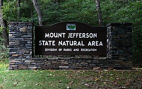
| Mount Jefferson State Natural Area | |
|---|---|
 | |
| Location | Ashe, North Carolina, United States |
| Coordinates | 36°24′03″N 81°27′46″W / 36.40083°N 81.46278°W[1] |
| Area | 1,188 acres (4.81 km2)[2] |
| Elevation | 4,660 ft (1,420 m) |
| Established | 1956 |
| Named for | Mount Jefferson |
| Governing body | North Carolina Division of Parks and Recreation |
| Website | www |
| Designated | 1974 |
Mount Jefferson State Natural Area is a 1,188-acre (4.81 km2)[2] North Carolina state park in Ashe County, North Carolina in the United States. Located near Jefferson, North Carolina, it includes the peak of Mount Jefferson, named for Thomas Jefferson and his father Peter, who owned land nearby and surveyed the North Carolina-Virginia border in 1749. In 1974, Mount Jefferson State Natural Area was designated as a National Natural Landmark by the National Park Service.[3]
- ^ United States Geological Survey. "Mount Jefferson State Park, USGS Jefferson (NC) Topo Map". TopoQuest. Retrieved July 5, 2008.
- ^ a b Cite error: The named reference
ParkSizewas invoked but never defined (see the help page). - ^ "National Natural Landmarks - National Natural Landmarks (U.S. National Park Service)". www.nps.gov. Retrieved March 25, 2019.
Year designated: 1974

