| Mount Kazbegi | |
|---|---|
 Mount Kazbegi | |
| Highest point | |
| Elevation | 5,054 m (16,581 ft)[1][2] |
| Prominence | 2,353 m (7,720 ft)[1] |
| Isolation | 113.6 km (70.6 mi) |
| Listing | Ultra |
| Coordinates | 42°41′57″N 44°31′06″E / 42.69917°N 44.51833°E[1] |
| Naming | |
| Native name |
|
| Geography | |
| Location | |
| Countries |
|
| Parent range | Lateral Range Caucasus |
| Geology | |
| Mountain type | Stratovolcano (dormant) |
| Last eruption | 750 BCE ± 50 years |
| Climbing | |
| First ascent | Yosif Buzurtanov (late 18th century)[4][5] |
| Easiest route | Basic snow/ice climb |
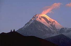
Mount Kazbek or Mount Kazbegi[a] is a dormant stratovolcano and one of the major mountains of the Caucasus, located in Georgia, just south of the border with Russia.[6]
Lying at 5,054 meters (16,581 ft) above at sea level, Mount Kazbek is the highest mountain in Eastern Georgia. It is also the third-highest peak in the country (after Mount Shkhara and Janga). Kazbegi is the second-highest volcanic summit in the Caucasus, after Mount Elbrus. The summit lies directly to the west of the town of Stepantsminda and is the most prominent geographic feature of the area.[6] The last eruption occurred c. 750 BCE.[6]
- ^ a b c "European Russia and the Caucasian States: Ultra-Prominence Page". peaklist.org. Retrieved 2014-05-25.
- ^ "Gora Kazbek, Georgia". Peakbagger.com. Retrieved 2015-05-25.
- ^ Страны Мира. ОЛМА Медиа Групп. 1974. p. 168. ISBN 978-5-94849-423-4.
- ^ Арджеванидзе 1954, p. 227.
- ^ Дахкильгов 1989, p. 99.
- ^ a b c "Kazbek". Global Volcanism Program. Smithsonian Institution. Retrieved 2021-06-24.
Cite error: There are <ref group=lower-alpha> tags or {{efn}} templates on this page, but the references will not show without a {{reflist|group=lower-alpha}} template or {{notelist}} template (see the help page).

