| Mount Kita | |
|---|---|
| 北岳 | |
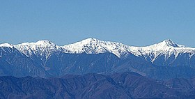
 Mount Kita viewed from Mount Nakashirane | |
| Highest point | |
| Elevation | 3,193 m (10,476 ft)[1] |
| Prominence | 2,239 m (7,346 ft)[2] |
| Listing | 100 Famous Japanese Mountains Ultra |
| Coordinates | 35°40′27″N 138°14′12″E / 35.67417°N 138.23667°E[2] |
| Naming | |
| English translation | northern peak |
| Language of name | Japanese |
| Pronunciation | [ki̥tadake] |
| Geography | |
| Location | Minami-Alps, Yamanashi Prefecture, Japan |
| Parent range | Akaishi Mountains |
| Topo map(s) | Geographical Survey Institute (国土地理院, Kokudochiriin) 25000:1 仙丈ヶ岳, 50000:1 市野瀬 |
| Climbing | |
| Easiest route | Hike |

Mount Kita (北岳, Kita-dake) is a mountain of the Akaishi Mountains−"Southern Alps" (南アルプス Minami-Arupusu), in Yamanashi Prefecture, Japan.
It is the second tallest mountain in Japan, after Mount Fuji, and is known as "the Leader of the Southern Alps".[3] It is included in the 100 Famous Japanese Mountains. It is located in Minami Alps National Park, near the city of Minami-Alps, Yamanashi Prefecture.
- ^ Geographical Survey Institute map 25000:1 仙丈ヶ岳 accessed online 8 April 2008.
- ^ a b "Japan Ultra-Prominences". Peaklist.org. Retrieved 2015-01-01.
- ^ Mount Kita Archived 2011-07-22 at the Wayback Machine. (in Japanese) Minami Alps Net. Accessed July 1, 2008.
