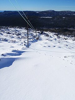
| Mount Mawson | |
|---|---|
 Top of Mawson Run | |
| Location | Mount Mawson, Mount Field |
| Nearest major city | Hobart |
| Top elevation | 1,320 metres (4,330 ft) |
| Base elevation | 1,250 metres (4,100 ft) AHD[1] |
| Trails | 5 |
| Lift system | 4 rope tows |
| Website | mtmawson |
Location in Tasmania | |
| Highest point | |
| Elevation | 1,318 m (4,324 ft)AHD[2] |
| Prominence | 51 m (167 ft)[2] |
| Listing | List of highest mountains of Tasmania |
| Coordinates | 42°21′43″S 146°34′28″E / 42.36194°S 146.57444°E[3] |
| Geography | |
| Location | Southern Tasmania, Australia |
| Geology | |
| Rock age | Jurassic |
| Mountain type | Dolerite |
Mount Mawson is a mountain and club skifield situated within the Mount Field National Park in southern Tasmania, Australia.
The mountain has an elevation of 1,318 metres (4,324 ft) above sea level.[2] Mount Mawson's summit rises to 1,320 metres (4,330 ft)[citation needed] above sea level slightly lower than the 1,460 metres (4,790 ft) at Ben Lomond ski-field in northern Tasmania.
By road, the mountain is located 89 kilometres (55 mi) north west of Hobart and 232 kilometres (144 mi) from Launceston.
- ^ Cite error: The named reference
mmwas invoked but never defined (see the help page). - ^ a b c "Mount Mawson, Australia". Peakbagger.com. Retrieved 31 May 2017.
- ^ "Mount Mawson". Gazetteer of Australia online. Geoscience Australia, Australian Government.
