| Mount Olive | |
|---|---|
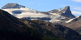
 Mount Olive (left) with Saint Nicholas Peak (right) seen from Bow Lake | |
| Highest point | |
| Elevation | 3,126 m (10,256 ft)[1] |
| Prominence | 146 m (479 ft)[2] |
| Listing | |
| Coordinates | 51°36′40″N 116°29′30″W / 51.61111°N 116.49167°W[3] |
| Geography | |
| Country | Canada |
| Provinces | Alberta and British Columbia |
| Protected areas | |
| Parent range | Park Ranges Canadian Rockies |
| Topo map | NTS 82N9 Hector Lake[3] |
| Climbing | |
| First ascent | 1927 M. Cropley, F.A. Gambs, N.L. Goodrich, L. Grassi[1][2] |
Mount Olive is located N of the head of the Yoho River on the Continental Divide, on the Alberta-British Columbia border, in both Banff National Park and Yoho National Park.[4] It lies on the eastern edge of the Wapta Icefield, and is part of the Waputik Mountains. It was named in 1898 by H.B. Dixon after his wife Dixon, Olive.[1][2][4]
- ^ a b c "Mount Olive". cdnrockiesdatabases.ca. Retrieved 2019-06-07.
- ^ a b c "Mount Olive". Bivouac.com. Retrieved 2019-06-07.
- ^ a b "Mount Olive (Alberta)". Geographical Names Data Base. Natural Resources Canada. Retrieved 2023-10-14.
- ^ a b "Mount Olive". BC Geographical Names. Retrieved 2023-10-14.

