Mount Pleasant, Ohio | |
|---|---|
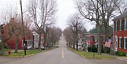
 Union Street, Mount Pleasant Historic District | |
 Location of Mount Pleasant in Jefferson County and the state of Ohio | |
| Coordinates: 40°10′33″N 80°47′59″W / 40.17583°N 80.79972°W | |
| Country | United States |
| State | Ohio |
| County | Jefferson |
| Township | Mount Pleasant |
| Area | |
• Total | 0.26 sq mi (0.66 km2) |
| • Land | 0.26 sq mi (0.66 km2) |
| • Water | 0.00 sq mi (0.00 km2) |
| Elevation | 1,217 ft (371 m) |
| Population (2020) | |
• Total | 394 |
| • Density | 1,545.10/sq mi (596.85/km2) |
| Time zone | UTC-5 (Eastern (EST)) |
| • Summer (DST) | UTC-4 (EDT) |
| ZIP code | 43939 |
| Area code | 740 |
| FIPS code | 39-52976[3] |
| GNIS feature ID | 2399415[2] |
Mount Pleasant is a village in southern Jefferson County, Ohio, United States. The population was 394 at the 2020 census. It is part of the Weirton–Steubenville metropolitan area. Founded in 1803 by anti-slavery Quakers, the village was an early center of abolitionist activity and a well-known haven for fugitive slaves on the Underground Railroad.
- ^ "ArcGIS REST Services Directory". United States Census Bureau. Retrieved September 20, 2022.
- ^ a b U.S. Geological Survey Geographic Names Information System: Mount Pleasant, Ohio
- ^ "U.S. Census website". United States Census Bureau. Retrieved January 31, 2008.