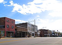
Mount Pleasant, Tennessee | |
|---|---|
 Mount Pleasant Main Street, October 2016 | |
| Nickname: The Phosphate Capital of the World | |
 Location of Mount Pleasant in Maury County, Tennessee. | |
| Coordinates: 35°32′42″N 87°11′55″W / 35.54500°N 87.19861°W | |
| Country | United States |
| State | Tennessee |
| County | Maury |
| Government | |
| • Type | City Manager-Commission |
| • City Manager | Kate Collier |
| • Mayor | Bill White |
| Area | |
| • Total | 12.60 sq mi (32.64 km2) |
| • Land | 12.58 sq mi (32.57 km2) |
| • Water | 0.03 sq mi (0.07 km2) |
| Elevation | 676 ft (206 m) |
| Population | |
| • Total | 4,784 |
| • Density | 380.38/sq mi (146.87/km2) |
| Time zone | UTC-6 (Central (CST)) |
| • Summer (DST) | UTC-5 (CDT) |
| ZIP code | 38474 |
| Area code | 931 |
| FIPS code | 47-51080[3] |
| GNIS feature ID | 1306783[4] |
| Website | www |


Mount Pleasant is a city in Maury County, Tennessee, United States. Mount Pleasant was the birthplace of 19th-century writer and humorist Samuel R. Watkins and formerly titled "The Phosphate Capital of the World." The population was 4,561 at the 2010 census, and 4,784 in 2020.
- ^ "ArcGIS REST Services Directory". United States Census Bureau. Retrieved October 15, 2022.
- ^ Cite error: The named reference
USCensusDecennial2020CenPopScriptOnlywas invoked but never defined (see the help page). - ^ "U.S. Census website". United States Census Bureau. Retrieved January 31, 2008.
- ^ "US Board on Geographic Names". United States Geological Survey. October 25, 2007. Retrieved January 31, 2008.
