| Mount Nimba | |
|---|---|
| Nyamba (Niemba) Tun - Mt. Richard-Molard | |
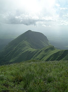
 Grass at the summit of Mount Nimba | |
| Highest point | |
| Elevation | 1,752 m (5,748 ft) |
| Prominence | 1,343 m (4,406 ft) |
| Listing | Country high point |
| Coordinates | 7°37′21″N 8°24′20″W / 7.62250°N 8.40556°W |
| Geography | |
| Location | Liberia - Ivory Coast – Guinea |
| Parent range | Nimba Range |
Mount Nimba (French: Mont Nimba) is a mountain along the border of Guinea, Ivory Coast and Liberia in West Africa. The summit is on the border of Guinea and Ivory Coast and at 1,752 m (5,748 ft) is the highest peak for both countries and of the Nimba Range. The mountain is part of the Guinea Highlands, which straddles the borders between the three countries. The nearest major settlements are the town Yekepa in Liberia and the towns of Bossou and N'Zoo in Guinea.[1]


