| Mount Saint Elias | |
|---|---|
| Yasʼéitʼaa Shaa or Was'eitushaa | |
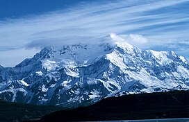
 Mount St. Elias from Icy Bay, Alaska | |
| Highest point | |
| Elevation | 18,008 ft (5,489 m)[1] NAVD88 |
| Prominence | 11,312 ft (3,448 m)[1] |
| Parent peak | Mount Logan |
| Isolation | 25.6 mi (41.3 km)[1] |
| Listing | |
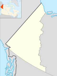
| Coordinates | 60°17′32″N 140°55′53″W / 60.29222°N 140.93139°W[2] |
| Geography | |
| Location | Yakutat City and Borough, Alaska, U.S./Yukon, Canada |
| Parent range | Saint Elias Mountains |
| Topo map(s) | USGS Mt. Saint Elias NTS 115C7 Newton Glacier[3] |
| Climbing | |
| First ascent | 1897 by Duke of the Abruzzi |
| Easiest route | glacier/snow/ice climb |
Mount Saint Elias (Was'eitushaa also designated Boundary Peak 186),[2][4] the second-highest mountain in both Canada and the United States, stands on the Yukon and Alaska border about 26 miles (42 km) southwest of Mount Logan,[5] the highest mountain in Canada. The Canadian side of Mount Saint Elias forms part of Kluane National Park and Reserve, while the U.S. side of the mountain is located within Wrangell-St. Elias National Park and Preserve.
- ^ a b c "Mount Saint Elias, Alaska-Yukon". Peakbagger.com. Retrieved December 30, 2015.
- ^ a b Cite error: The named reference
gniswas invoked but never defined (see the help page). - ^ Cite error: The named reference
cgndbwas invoked but never defined (see the help page). - ^ Cite error: The named reference
NPSnamewas invoked but never defined (see the help page). - ^ Cite error: The named reference
cmewas invoked but never defined (see the help page).

