| Mount San Antonio | |
|---|---|
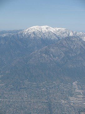
 South face of Mt. San Antonio, seen above Upland, California | |
| Highest point | |
| Elevation | 10,064 ft (3,068 m) The National Map of the United States[1] |
| Prominence | 6,224 ft (1,897 m) ↓ Cajon Pass[2] |
| Isolation | 42.52 mi (68.43 km) → San Bernardino Peak |
| Listing | |
| Coordinates | 34°17′20″N 117°38′48″W / 34.2888927°N 117.6467218°W[4] |
| Naming | |
| Etymology | Saint Anthony of Padua |
| Geography | |
| Location | Los Angeles / San Bernardino counties, California U.S. |
| Parent range | San Gabriel Mountains |
| Topo map | USGS Mount San Antonio |
| Geology | |
| Mountain type | Granitic |
| Climbing | |
| Easiest route | Ski lift to Baldy Notch, Devil's Backbone Trail (hike) |
Mount San Antonio, commonly referred to as Mount Baldy or Old Baldy, is a 10,064 ft (3,068 m) summit in the San Gabriel Mountains on the border of Los Angeles and San Bernardino counties of California.[4][5] Lying within the San Gabriel Mountains National Monument and Angeles National Forest, it is the highest point within the mountain range, the County of Los Angeles, and the Los Angeles metropolitan area.
Mount San Antonio's sometimes snow-capped peaks are visible on clear days and dominate the view of the Los Angeles Basin skyline. The peak and a subsidiary one to the west form a double summit of a steep-sided east–west ridge. The summit is accessible via a number of connecting ridges along hiking trails from the north, east, south, and southwest.
- ^ United States Geological Survey (2018-10-22). "The National Map – Advanced Viewer" (Map). The National Map. Retrieved 2020-07-09.
- ^ "Mount San Antonio". Peakbagger.com. Retrieved 2009-01-25.
- ^ "Hundred Peaks Section List". Angeles Chapter, Sierra Club. Retrieved 2016-08-10.
- ^ a b "Mount San Antonio". Geographic Names Information System. United States Geological Survey, United States Department of the Interior. Retrieved 2019-09-16.
- ^ "Mount San Antonio (Mount Baldy)". SummitPost.org. Retrieved 2017-01-10.

