| Mount Sanford | |
|---|---|
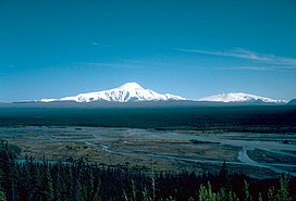
 Mount Sanford (left) and Mount Wrangell in 1980 | |
| Highest point | |
| Elevation | 16,237 ft (4,949 m)[1] NAVD88 |
| Prominence | 7,687 ft (2,343 m)[1] |
| Isolation | 40.3 mi (64.8 km)[1] |
| Listing | |
| Coordinates | 62°12′50″N 144°07′44″W / 62.2138889°N 144.1288889°W[2] |
| Geography | |
 | |
| Interactive map of Mount Sanford | |
| Location | Wrangell-St. Elias National Park and Preserve, Alaska, U.S. |
| Parent range | Wrangell Mountains |
| Topo map | USGS Gulkana A-1 |
| Geology | |
| Mountain type | Shield volcano[3] |
| Last eruption | 320,000 years ago |
| Climbing | |
| First ascent | July 21, 1938 by Terris Moore and Bradford Washburn[4] |
| Easiest route | Sheep Glacier (North Ramp) Route, Alaska Grade 2[4] |
Mount Sanford is a shield volcano[3] in the Wrangell Volcanic Field, in eastern Alaska near the Copper River. It is the sixth highest mountain in the United States and the third highest volcano behind Mount Bona and Mount Blackburn. The south face of the volcano, at the head of the Sanford Glacier, rises 8,000 feet (2,400 m) in 1 mile (1,600 m) resulting in one of the steepest gradients in North America.
- ^ a b c Cite error: The named reference
PBwas invoked but never defined (see the help page). - ^ "Mount Sanford". Geographic Names Information System. United States Geological Survey, United States Department of the Interior. Retrieved 2008-12-23.
- ^ a b "Sanford". Global Volcanism Program. Smithsonian Institution. Retrieved 2021-01-04.
- ^ a b Cite error: The named reference
wood_coombswas invoked but never defined (see the help page).
