| Mount Scott | |
|---|---|
 Mount Scott, the highest peak in the Wichita Mountains Wildlife Refuge, north of Lawton. | |
| Highest point | |
| Elevation | 2,464 ft (751 m) NAVD 88[1] |
| Prominence | 824 ft (251 m)[2] |
| Coordinates | 34°44′40″N 98°31′55″W / 34.744561917°N 98.5319088°W[1] |
| Geography | |
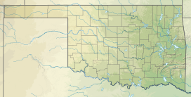
| Location | Comanche County, Oklahoma, U.S. |
| Parent range | Wichita Mountains |
| Topo map | USGS Mount Scott |
| Geology | |
| Rock age | Cambrian Period[3] |
| Mountain type | Igneous[3] |
| Climbing | |
| Easiest route | Paved Road |
Mount Scott (Comanche: Pisaroya, "Big Mountain")[4] is a prominent mountain just to the northwest of Lawton, Oklahoma rising to a height of 2,464 feet (751 m)[5] and is located in the Wichita Mountains near Fort Sill Military Reservation and lies in the Wichita Mountains National Wildlife Refuge (WMWR). The US Fish and Wildlife Service is responsible for the maintenance of the area. Visitors can reach the summit by car or bicycle via a three-mile paved road. Hiking is allowed, although there are no formal trails and the paved road is open to pedestrians and bicycles from 6am to 9:30 am only. Mount Scott is also popular for its numerous rock climbing areas. The peak was named in honor of General Winfield Scott.[6]
- ^ a b "Mt Scott Reset". NGS Data Sheet. National Geodetic Survey, National Oceanic and Atmospheric Administration, United States Department of Commerce. Retrieved 2016-06-01.
- ^ "Mount Scott, Oklahoma". Peakbagger.com. Retrieved 2008-05-24.
- ^ a b "America's Volcanic Past: Oklahoma". US Geological Survey. Archived from the original on 2008-05-17. Retrieved 2008-05-24.
- ^ Gelo, Daniel (January 2000). "Comanche Land and Ever Has Been": A Native Geography of the Nineteenth-Century Comanchería". The Southwestern Historical Quarterly. 103 (3): 273–307. Retrieved 26 November 2022.
- ^ "Wichita Mountains Wildlife Refuge". US Fish and Wildlife Service. Retrieved 2008-05-24.
- ^ "Oklahoma Historical Society's Encyclopedia of Oklahoma History and Culture: Fort Sill". Archived from the original on 2014-07-23. Retrieved 2014-08-09.
