| Mount Tapulao | |
|---|---|
| High Peak | |
 Pine forest of Mount Tapulao | |
| Highest point | |
| Elevation | 2,037 m (6,683 ft)[1] |
| Prominence | 2,015 m (6,611 ft)[2] |
| Listing | Ultra |
| Coordinates | 15°28′51″N 120°7′16″E / 15.48083°N 120.12111°E |
| Geography | |
| Location | Luzon |
| Country | Philippines |
| Region | Central Luzon |
| Province | Zambales |
| Municipality | Palauig |
| Parent range | Zambales Mountains |
| Climbing | |
| Easiest route | Dampay Resettlement Area, Brgy. Salaza, Palauig |
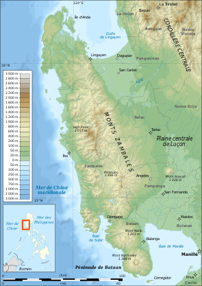
Mount Tapulao (also known as High Peak) is the highest mountain in the Zambales Mountain Range and in the province of Zambales in the Philippines. The peak, which rises to an elevation of 2,037 metres (6,683 ft) above sea level, and is located in the municipality of Palauig, Zambales. Its name is derived from the abundance of Sumatran Pine trees in the area, known in Zambal as tapolaw.[1][3]
The mountain was once a site of a large-scale chromite mining operations.[1] The destruction of the beautiful natural scenery is visible in the mine pits on the summit as well as other related structures along the trail. The summit offers a 360-degree vista from where you can see the other Zambales mountains on the eastern side, Lingayen Gulf to the north, and on the western side, the Zambales lowlands and the South China Sea stretching to as far south as Pundaquit in San Antonio, Zambales.

- ^ a b c (2007-09-01). "Mt. Tapulao (2,037+)". Pinoy Mountaineer. Retrieved on 2012-02-11.
- ^ "Philippines Mountains: Ultras. Listed as "High Peak (Luzon)"". peaklist.org. Retrieved 2023-02-27.
- ^ "Zambales Mountains" Archived 2013-07-18 at the Wayback Machine. NewCAPP. Retrieved on 2012-02-15.
