| Tŝ’ilʔoŝ | |
|---|---|
| Mount Tatlow | |
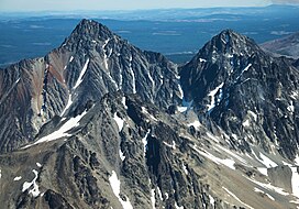
 Tŝ’ilʔoŝ aerial, west aspect | |
| Highest point | |
| Elevation | 3,063 m (10,049 ft)[1][2] |
| Prominence | 1,613 m (5,292 ft)[1][2] |
| Parent peak | Altruist Mountain (3064 m)[2] |
| Listing | |
| Coordinates | 51°23′03″N 123°51′51″W / 51.38417°N 123.86417°W[1] |
| Naming | |
| Native name | Tŝ’ilʔoŝ (Chilcotin) |
| Pronunciation | sigh-loss |
| Geography | |
| Location | Central Interior of British Columbia, Canada |
| Parent range | Chilcotin Ranges |
| Topo map | NTS 92P5 Jesmond |
Tŝ’ilʔoŝ, also known as Mount Tatlow, is one of the principal summits of the Chilcotin Ranges subdivision of the Pacific Ranges of the Coast Mountains of southern British Columbia. Standing on an isolated ridge between the lower end of Chilko Lake and the Taseko Lakes, it is 3,063 m (10,049 ft) in elevation.
Southeast across the Taseko Lakes is Taseko Mountain 3,063 m (10,049 ft), the highest summit between those lakes and the Fraser River, while directly south beyond Yohetta Valley (a deep valley which connects the relative lowlands around Chilko and Taseko Lakes is the massif containing Monmouth Mountain 3,182 m (10,440 ft). Southwest across Chilko Lake is Mount Good Hope 3,242 m (10,636 ft) and due west, also across Chilko Lake, is Mount Queen Bess 3,298 m (10,820 ft), the highest peak east of the Homathko River before the Waddington Range massif, which is at the core of the range and contains Mount Waddington 4,016 m (13,176 ft).
- ^ a b c "British Columbia and Alberta: The Ultra-Prominence Page". Peaklist.org. Retrieved 2012-11-04.
- ^ a b c "Mount Tatlow". Bivouac.com. Retrieved 2021-06-17.
