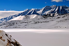
| Mount Timpanogos Wilderness | |
|---|---|
 Mount Timpanogos, Winter 2008 | |
| Location | Utah County, Utah United States |
| Nearest city | Pleasant Grove |
| Coordinates | 40°23′0″N 111°39′0″W / 40.38333°N 111.65000°W |
| Area | 10,518 acres (42.56 km2) |
| Established | 1984 |
| Governing body | U.S. Forest Service |


Mount Timpanogos Wilderness is a 10,518-acre (42.56 km2) wilderness area protecting Mount Timpanogos and the surrounding area in Utah, United States. It is located in the front range of the Wasatch Mountain Range, between American Fork Canyon on the north and Provo Canyon on the south, within the Uinta-Wasatch-Cache National Forest on the north eastern edge of Utah County, Utah.[1] The wilderness area receives fairly heavy use due to its proximity to the heavily populated cities of Provo and Salt Lake City.[2] It is bordered on the north by the Lone Peak Wilderness.
- ^ Mount Timpanogos Wilderness - Wilderness.net
- ^ Mount Timpanogos Wilderness Archived 2010-05-13 at the Wayback Machine - GORP

