| Mount Tom Range | |
|---|---|
| Metacomet Ridge | |
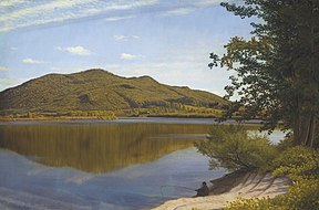
 The range's peaks depicted in an 1865 painting by Thomas Charles Farrer (1839–1891), oil on canvas | |
| Highest point | |
| Peak | Mount Tom |
| Elevation | 1,202 ft (366 m) |
| Coordinates | 42°14′30″N 72°38′53″W / 42.24167°N 72.64806°W |
| Dimensions | |
| Length | 4.5 mi (7.2 km) east-west |
| Geography | |
| Country | United States |
| State | Massachusetts |
| Geology | |
| Rock age(s) | Triassic and Jurassic |
| Rock type(s) | fault-block, igneous and sedimentary |
The Mount Tom Range is a traprock mountain range located in the Connecticut River Valley of Massachusetts. It is a subrange of the Appalachians and part of the Metacomet Ridge that extends from Long Island Sound near New Haven, Connecticut, north through the Connecticut River Valley of Massachusetts to nearly the Vermont border. A popular outdoor recreation resource, the range is known for its continuous west facing cliffs and its rugged, scenic character. It is also notable for its unique microclimate ecosystems and rare plant communities, as well as significant historic sites, such as the ruins of the 18th century Eyrie House located on Mount Nonotuck.[1][2]
- ^ *The Metacomet-Monadnock Trail Guide. 9th Edition. The Appalachian Mountain Club. Amherst, Massachusetts, 1999.
- ^ Farnsworth, ElizabethJ. "Metacomet-Mattabesett Trail Natural Resource Assessment. Archived 2007-08-07 at the Wayback Machine" 2004. PDF file cited November 1, 2007.
