| Mount Trumbull Wilderness | |
|---|---|
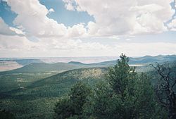
 A view of Mt. Trumbull from a nearby cinder cone | |
| Location | Mohave County, Arizona, United States |
| Nearest city | Fredonia, Arizona |
| Coordinates | 36°24′29″N 113°07′41″W / 36.408°N 113.128°W |
| Area | 7,880 acre (31 km2) |
| Established | 1984 |
| Governing body | Bureau of Land Management |
The Mount Trumbull Wilderness is a 7,880 acre (31 km2) wilderness area located on the Uinkaret Plateau in the Arizona Strip. It is managed by the Bureau of Land Management.

The Mount Trumbull Wilderness is north of Grand Canyon National Park and in the Grand Canyon-Parashant National Monument. It is approximately 60 miles southwest of Fredonia, Arizona and about 60 miles south of St. George, Utah. It is about 7 miles north of the Mount Logan Wilderness.
The namesake of the wilderness, Mt. Trumbull, is 8,028 feet (2,446m) at its highest point. A 2.5 mile trail to the top can be accessed from Mohave County Road 5. The mountain was named by John Wesley Powell after the Illinois Senator Lyman Trumbull.[1]
- ^ Powell, John Wesley. The Exploration of the Colorado River and its Canyons. 1961, Dover Publications, New York.