This article needs additional citations for verification. (March 2023) |
| Mount Utatsu | |
|---|---|
| 卯辰山 | |
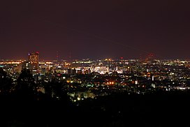
 View from Mount Utatsu of downtown Kanazawa. | |
| Highest point | |
| Elevation | 149 m (489 ft)[1] |
| Prominence | 33 m (108 ft)[1] |
| Listing | Mountains of Japan |
| Coordinates | 36°34′24″N 136°40′40″E / 36.5732°N 136.6778°E[2] |
| Naming | |
| Language of name | Japanese |
| Geography | |
Mount Utatsu (卯辰山, Utatsu-yama) is a mountain in Kanazawa, Ishikawa Prefecture, Japan. It is also known by a number of other names, including Mount Mukai (向山, Mukai-yama), Mount Mukō (夢香山, Mukō-yama), Mount Garyū (臥竜山, Garyū-zan), and Mount Kasuga (春日山, Kasuga-yama). It is visible to the east of Kanazawa Castle and has Toyokuni Shrine located on its slopes.
The summit of Mount Utatsu is used as a secondary triangulation point (named "Kanazawa") by the Geographical Survey Institute of Japan.
- ^ a b "Mt. Utatsu". peakvisor.com. Retrieved 10 March 2023.
- ^ "Topographic map of Mount Utatsu". opentopomap.org. Retrieved 2023-06-20.
