| Mount Wrangell | |
|---|---|
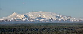
 Mount Wrangell seen from the west | |
| Highest point | |
| Elevation | 14,163 ft (4,317 m)[1] NAVD88 |
| Prominence | 5,613 ft (1,711 m)[1] |
| Isolation | 14.79 mi (23.8 km)[1] |
| Listing | |
| Coordinates | 62°00′21″N 144°01′10″W / 62.00572°N 144.01935°W[1] |
| Naming | |
| Etymology | Ferdinand von Wrangel |
| Geography | |
 | |
| Interactive map of Mount Wrangell | |
| Location | Wrangell-St. Elias National Park and Preserve, Alaska, U.S. |
| Parent range | Wrangell Mountains |
| Topo map | USGS Gulkana A-1 |
| Geology | |
| Rock age | Pleistocene |
| Mountain type | Shield volcano |
| Volcanic field | Wrangell Volcanic Field |
| Last eruption | March–April 1930[2] |
Mount Wrangell, (Ahtna: K’ełt’aeni, or K’ełedi when erupting)[3] is a massive shield volcano located in Wrangell-St. Elias National Park and Preserve in southeastern Alaska, United States. The shield rises over 12,000 feet (3,700 m) above the Copper River to its southwest. Its volume is over 220 cubic miles (920 km3), making it more than twice as massive as Mount Shasta in California, the largest stratovolcano by volume in the Cascades. It is part of the Wrangell Mountains as well as the Wrangell Volcanic Field, which extends for more than 250 kilometers (160 mi) across Southcentral Alaska into the Yukon Territory in Canada, and has an eruptive history spanning the time from Pleistocene to Holocene.
- ^ a b c d "Mount Wrangell, Alaska". Peakbagger.com. Retrieved 2016-01-06.
- ^ Alaska Volcano Observatory, Mount Wrangell activity - 1930, Motyka, 1983, Retrieved Dec. 8. 2021.
- ^ Smelcer, John. "Wrangell-St. Elias Mountains in Ahtna Country" (PDF). Archived from the original (PDF) on 19 August 2011. Retrieved 14 December 2014.
