| Mount Yake | |
|---|---|
| 焼岳 | |
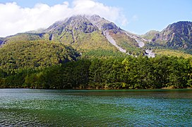
 Mount Yake behind Lake Taishō | |
| Highest point | |
| Elevation | 2,455 m (8,054 ft)[1] |
| Listing | |
| Coordinates | 36°13′37″N 137°35′13″E / 36.227°N 137.587°E[2] |
| Naming | |
| English translation | Burnt mountain |
| Language of name | Japanese |
| Geography | |
| Country | Japan |
| Prefectures | Gifu and Nagano |
| Protected area | Chūbu-Sangaku National Park |
| Cities | Takayama and Matsumoto |
| Parent range | Hida Mountains |
| Geology | |
| Rock age | 20,000 years Late Pleistocene[3] |
| Mountain type | Active stratovolcano |
| Rock type(s) | Andesite, Dacite[3][2] |
| Last eruption | February 11, 1995[4][3] |
| Climbing | |
| Easiest route | Hike |
Mount Yake (焼岳, Yake-dake) literally, "Burning mountain" is an active volcano in the Hida Mountains, lying between Matsumoto, Nagano Prefecture, and Takayama, Gifu Prefecture, Japan. It is one of the 100 Famous Japanese Mountains, reaching 2,455 m (8,054 ft) at the highest peak.
- ^ "Topographic map of Mount Yake". opentopomap.org. Retrieved 2023-04-03.
- ^ a b "Yakedake". Global Volcanism Program. Smithsonian Institution. Retrieved 2021-06-24.
- ^ a b c "Yakedake". Geological Survey of Japan. Retrieved 2023-04-03.
- ^ "Yakedake (Eruption History)". Global Volcanism Program. Smithsonian Institution. Retrieved 2023-04-03.
