| Mountain Fork Mountain Fork of the Little River | |
|---|---|
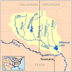
 Map of the Little River watershed showing the Mountain Fork | |
 | |
| Physical characteristics | |
| Source | |
| • location | Ouachita Mountains, Oklahoma |
| Mouth | Little River |
• location | McCurtain County, Oklahoma |
• coordinates | 33°57′05″N 94°34′32″W / 33.95139°N 94.57556°W |
| Length | 98 mi (158 km) |
| Discharge | |
| • location | Eagletown, Oklahoma |
| • average | 1,430 cubic feet per second (40 cubic metres per second) |
Mountain Fork, also known as the Mountain Fork of the Little River, is a 98-mile-long (158 km)[1] tributary of the Little River in western Arkansas and southeastern Oklahoma in the United States. Via the Little and Red rivers, it is part of the watershed of the Mississippi River. The stream rises in the Ouachita Mountains. Broken Bow Lake is an artificial lake along the course of the Mountain Fork. The stream is known for canoeing, kayaking, and sport fishing, including for stocked trout.
- ^ U.S. Geological Survey. National Hydrography Dataset high-resolution flowline data. The National Map, accessed June 3, 2011