| Mountfield | |
|---|---|
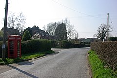
 The junction of Church Road and Hoath Hill, Mountfield | |
Location within East Sussex | |
| Area | 15.3 km2 (5.9 sq mi) [1] |
| Population | 616 (Parish-2011)[2] |
| • Density | 97/sq mi (37/km2) |
| OS grid reference | TQ742203 |
| • London | 46 miles (74 km) NW |
| District | |
| Shire county | |
| Region | |
| Country | England |
| Sovereign state | United Kingdom |
| Post town | ROBERTSBRIDGE |
| Postcode district | TN32 |
| Dialling code | 01580 |
| Police | Sussex |
| Fire | East Sussex |
| Ambulance | South East Coast |
| UK Parliament | |
| Website | The Parish of Mountfield website |

Mountfield is a village and civil parish in the Rother district of East Sussex, England, and three miles (5 km) north-west of Battle. It is mentioned in the Domesday Book.[3]
The parish church is dedicated to All Saints. Mountfield and Whatlington Church of England Primary School is at the road junction in the nearby hamlet of Johns Cross by the A21 and the A2100 roads further north. The parish includes the linear settlement of Vinehall Street, to the south from Johns Cross, which contains the independent Vinehall School.
- ^ "East Sussex in Figures". East Sussex County Council. Retrieved 26 April 2008.
- ^ "Civil Parish population 2011". Archived from the original on 14 January 2016. Retrieved 7 October 2015.
- ^ "Mountfield | Domesday Book". opendomesday.org. Retrieved 4 April 2022.
