| Mourilyan Queensland | |||||||||||||||
|---|---|---|---|---|---|---|---|---|---|---|---|---|---|---|---|
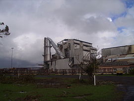
 The Mourilyan sugar mill after Cyclone Larry | |||||||||||||||
| Coordinates | 17°34′S 146°03′E / 17.567°S 146.050°E | ||||||||||||||
| Population | 509 (2021 census)[1] | ||||||||||||||
| Postcode(s) | 4858 | ||||||||||||||
| Location | |||||||||||||||
| LGA(s) | Cassowary Coast Region | ||||||||||||||
| State electorate(s) | Hill | ||||||||||||||
| Federal division(s) | Kennedy | ||||||||||||||
| |||||||||||||||
Mourilyan is a town and locality in the Cassowary Coast Region, Queensland, Australia.[2][3] It was established around the Mourilyan sugar mill which provided much of the employment in the area until it was destroyed by Cyclone Larry on 20 March 2006. In the 2021 census, the locality of Mourilyan had a population of 509 people.[1]
- ^ a b Cite error: The named reference
Census2021was invoked but never defined (see the help page). - ^ "Mourilyan – town (entry 23226)". Queensland Place Names. Queensland Government. Retrieved 12 March 2017.
- ^ "Mourilyan – locality (entry 45735)". Queensland Place Names. Queensland Government. Retrieved 12 March 2017.
