This article needs additional citations for verification. (November 2022) |
Mouscron
Moucron (Picard) Moeskroen (Dutch) | |
|---|---|
 | |
| Coordinates: 50°44′N 03°13′E / 50.733°N 3.217°E | |
| Country | |
| Community | French Community |
| Region | Wallonia |
| Province | Hainaut |
| Arrondissement | Tournai-Mouscron |
| Government | |
| • Mayor | Brigitte Aubert (Les Engagés) |
| • Governing party/ies | Les Engagés-MR |
| Area | |
• Total | 40.62 km2 (15.68 sq mi) |
| Population (2018-01-01)[1] | |
• Total | 58,234 |
| • Density | 1,400/km2 (3,700/sq mi) |
| Postal codes | 7700, 7711, 7712 |
| NIS code | 57096 |
| Area codes | 056 |
| Website | www.mouscron.be |
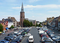
Mouscron (French pronunciation: [mukʁɔ̃] ; Dutch and West Flemish: Moeskroen, Dutch pronunciation: [muˈskrun] ; Picard and Walloon: Moucron) is a city and municipality of Wallonia located in the Belgian province of Hainaut, along the border with the French city of Tourcoing, which is part of the Lille metropolitan area.
The municipality consists of the following districts: Dottignies, Herseaux, Luingne, and Mouscron. In accordance with the national law, the municipality offers facilities for the Dutch speaking minority. Kortrijk, in Flanders, is located just to the north of Mouscron.
The city substantially grew during the 19th and early 20th century with the development of the textile industry in the north of France. The symbol of the city is the Hurlu: a character representing Protestant activists, who plundered the countryside during the Wars of Religion (16th century).
- ^ "Wettelijke Bevolking per gemeente op 1 januari 2018". Statbel. Retrieved 9 March 2019.


