Moxee | |
|---|---|
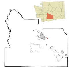
 Location of Moxee, Washington | |
| Coordinates: 46°33′23″N 120°23′14″W / 46.55639°N 120.38722°W | |
| Country | United States |
| State | Washington |
| County | Yakima |
| Founded | 1867 |
| Government | |
| • Mayor | LeRoy Lenseigne |
| Area | |
| • Total | 2.37 sq mi (6.13 km2) |
| • Land | 2.37 sq mi (6.13 km2) |
| • Water | 0.00 sq mi (0.00 km2) |
| Elevation | 1,063 ft (324 m) |
| Population | |
| • Total | 4,326 |
| • Estimate (2021)[2] | 4,405 |
| • Density | 1,734.57/sq mi (669.65/km2) |
| Time zone | UTC-8 (PST) |
| • Summer (DST) | UTC-7 (PDT) |
| ZIP code | 98936 |
| Area code | 509 |
| FIPS code | 53-47665[3] |
| GNIS feature ID | 1512489[4] |
| Website | cityofmoxee.us |
Moxee is a small suburban community southeast of Yakima, Washington. Yakima and Moxee are both north of the Yakama Indian Reservation in Yakima County, Washington, United States. The population of Moxee was 4,326 at the 2020 census.[1]
According to the Washington State Office of Financial Management,[5] Moxee ranked 5th of 279 eligible incorporated communities in population growth between 2000 and 2005.
- ^ a b "Explore Census Data". United States Census Bureau. Retrieved September 13, 2022.
- ^ Cite error: The named reference
USCensusEst2021was invoked but never defined (see the help page). - ^ "U.S. Census website". United States Census Bureau. Retrieved January 31, 2008.
- ^ "US Board on Geographic Names". United States Geological Survey. October 25, 2007. Retrieved January 31, 2008.
- ^ "April 1 official population estimates". ofm.wa.gov. Office of Financial Management. Retrieved June 6, 2014.