| Moylussa | |
|---|---|
| Maigh Lusa | |
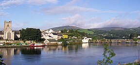
 View of Moylussa (on horizon right) from Ballina, County Tipperary | |
| Highest point | |
| Elevation | 532 m (1,745 ft)[1] |
| Prominence | 502 m (1,647 ft)[1] |
| Listing | County top (Clare), Marilyn |
| Coordinates | 52°50′01″N 8°31′21″W / 52.833502°N 8.522366°W |
| Geography | |
| Location | County Clare, Republic of Ireland |
| Parent range | Slieve Bernagh Mountains |
| OSI/OSNI grid | R6484375917 |
Moylussa (Irish: Maigh Lusa) is a mountain[2] in the Slieve Bernagh range in western Ireland, and the highest point in County Clare at 532 metres (1,745 ft).[1][3]
- ^ a b c "Moylussa". MountainViews. Retrieved 2 June 2019.
- ^ Listed as an Arderin – a category of Irish mountains greater than 500m high with 30m prominence.
- ^ Simon Edwardes (2013). "Moylussa". The Mountains of England and Wales. Retrieved 10 May 2014.
