Mt. Lebanon, Pennsylvania | |
|---|---|
 Uptown Mt. Lebanon along Washington Road (Rt. 19 Truck) | |
| Motto: "A Community with Character" | |
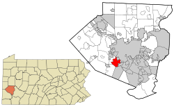
 Location in Allegheny County and in Pennsylvania | |
| Coordinates: 40°22′30″N 80°3′0″W / 40.37500°N 80.05000°W | |
| Country | United States |
| State | Pennsylvania |
| County | Allegheny |
| Government | |
| • Body | Commission |
| • President of Commission | Anne Swager Wilson (D) |
| Area | |
• Total | 6.08 sq mi (15.75 km2) |
| • Land | 6.08 sq mi (15.74 km2) |
| • Water | 0.00 sq mi (0.01 km2) |
| Population (2020) | |
• Total | 34,075 |
| • Density | 5,604.44/sq mi (2,163.49/km2) |
| Time zone | UTC-5 (EST) |
| • Summer (DST) | UTC-4 (EDT) |
| ZIP code | 15228 |
| FIPS code | 42-003-51696 |
| Website | www.MtLebanon.org |
Mt. Lebanon Historic District | |
| NRHP reference No. | 14000813[2] |
| Added to NRHP | September 30, 2014 |
Mt. Lebanon (locally /ˈlɛb.ə.nən/) is a township with home rule status in Allegheny County, Pennsylvania, United States. The population was 34,075 at the 2020 census. It is a suburb of Pittsburgh. Established in 1912 as Mount Lebanon, the township was a farming community. With the arrival of the first streetcar lines and the development of the first real estate subdivision, both in 1901, it became a streetcar suburb, offering residents the ability to commute to Downtown Pittsburgh.[3] Furthermore, the opening of the Liberty Tunnel in 1924 allowed easy automobile access to Pittsburgh. In 1975, the renamed Mt. Lebanon adopted one of the first home rule charters in Pennsylvania.[4][5]
- ^ "2016 U.S. Gazetteer Files". United States Census Bureau. Retrieved August 13, 2017.
- ^ "Weekly list of actions taken on properties: 9/29/14 through 10/03/14". National Park Service. October 10, 2014. Retrieved February 3, 2015.
- ^ "Mt. Lebanon History & Information". Archived from the original on July 3, 2009. Retrieved October 9, 2009.
- ^ Pennsylvania Code Title 302, Sec. 27.1-101 et seq. Archived September 13, 2011, at the Wayback Machine
- ^ Mtlebanon.org Archived September 27, 2007, at the Wayback Machine