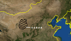
| Mu Us Desert | |
|---|---|
 Mu-Us Desert satellite image by NASA World Wind | |
| Floor elevation | 950 to 1,600 m (3,120 to 5,250 ft) |
| Length | 380 km (240 mi) |
| Width | 290 km (180 mi) |
| Area | 48,288 km2 (18,644 sq mi) |
| Naming | |
| Native name | |
| Geography | |
| Country | People's Republic of China |
| States | |
| Coordinates | 38°45′00″N 109°09′58″E / 38.7500°N 109.1660°E |
The Mu Us Desert (Mongolian: ᠮᠠᠭᠤ ᠤᠰᠤ magu usu Ordos: [mʊː ʊsʊ̆] "bad (lacking) water"), also known as the Maowusu Desert (simplified Chinese: 毛乌素沙漠; traditional Chinese: 毛烏素沙漠; pinyin: Máowūsù Shāmò), is a desert in the northern Ordos Plateau in Inner Mongolia, Northwest China.[1] Its southeastern end is crossed by the Ming Great Wall, and it forms the southern portion of the Ordos Desert.[2] The Wuding River drains the area, and then flows into the Ordos Loop of the Yellow River.[3][4]
- ^ Donovan Webster. 2002. China's Unknown Gobi Alashan. National Geographic 201(1):48-75
- ^ Yan, Changzhen; Wang, Tao; Han, Zhiwen. 2005. Using MODIS data to access land desertification in Ordos Plateau -- Mu Us Desert case study. Geoscience and Remote Sensing Symposium, 2005. IGARSS '05. Proceedings. 2005 IEEE International (Volume:4). DOI: 10.1109/IGARSS.2005.1525454
- ^ Reader's Digest Assoc., Inc. 2004. Reader's Digest Illustrated World Atlas. Pleasantville, N. Y., USA
- ^ Lovell, Julia. 2006. The Great Wall, China Against the World, 1000 BCE-AD 2000. Grove Press. New York, USA.