Muara Gembong | |
|---|---|
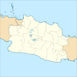
Location of Muara Gembong in West Java | |
| Coordinates: 5°59′S 107°2′E / 5.983°S 107.033°E | |
| Country | |
| Province | West Java |
| Regency | Bekasi |
| Area | |
| • Total | 140.09 km2 (54.09 sq mi) |
| Population (mid 2022 estimate)[1] | |
| • Total | 40,313 |
| • Density | 290/km2 (750/sq mi) |
| Time zone | UTC+7 (Indonesia Western Time) |
Muara Gembong is the most northerly district (kecamatan) of Bekasi Regency, in West Java, Indonesia. It covers an area of 140.09 km2, and had a population of 35,503 at the 2010 Census and 40,321 at the 2020 Census; the official estimate as at mid 2022 was 41,313, comprising 20,643 males and 19,670 females.[1] The administrative centre is located at Pantai Mekar, and the district is sub-divided into 6 villages (desa), all sharing a post-code of 17730, as listed below with their areas and their populations as at mid 2022.
| Kode Wilayah |
Name of Desa |
Area in km2 |
Population mid 2022 estimate |
|---|---|---|---|
| 32.16.17.2004 | Pantai Harapanjaya | 51.94 | 8,059 |
| 32.16.17.2001 | Pantai Mekar | 14.57 | 8,190 |
| 32.16.17.2005 | Pantai Sederhana | 12.00 | 4,321 |
| 32.16.17.2003 | Pantai Bakti | 34.42 | 7,525 |
| 32.16.17.2002 | Pantai Bahagia | 30.10 | 7,897 |
| 32.16.17.2006 | Jayasakti | 17.51 | 4,321 |
| 32.16.17 | Totals | 140.09 | 40,313 |
