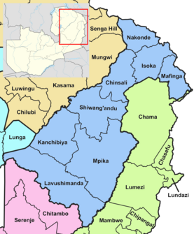
Muchinga | |
|---|---|
 Map of Zambia showing the Muchinga Province | |
| Country | |
| Capital | Chinsali |
| Government | |
| • Type | Provincial Administration |
| • Provincial Minister | Henry Sikazwe (UPND) |
| Area | |
| • Total | 87,806 km2 (33,902 sq mi) |
| Population (2022 census) | |
| • Total | 922,212 |
| • Density | 11/km2 (27/sq mi) |
| Districts | 7 |
| Website | www |
Muchinga Province is one of the ten provinces of Zambia. It is located in the northeast of the country and borders with Tanzania in the north, Malawi in the east, Eastern Province in the south, Central Province in the southwest, Luapula Province in the west, and Northern Province in the northwest. The administrative center of the province is Chinsali.
The name of the province originates from the Muchinga Escarpment, on which it predominantly sits.[1]
- ^ "Muchinga Escarpment". Archived from the original on 2019-04-16.