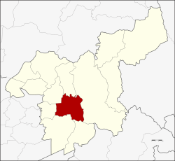
Mueang Saraburi
เมืองสระบุรี | |
|---|---|
 View Sleeping Shelter at Sam Lan WaterFall | |
 District location in Saraburi province | |
| Coordinates: 14°31′38″N 100°54′35″E / 14.52722°N 100.90972°E | |
| Country | Thailand |
| Province | Saraburi |
| Area | |
• Total | 301.6 km2 (116.4 sq mi) |
| Population (2000) | |
• Total | 106,107 |
| • Density | 350/km2 (910/sq mi) |
| Time zone | UTC+7 (ICT) |
| Postal code | 18000 |
| Geocode | 1901 |
Mueang Saraburi (Thai: เมืองสระบุรี) is the capital district (amphoe mueang) of Saraburi province, central Thailand.