Muhlenberg County | |
|---|---|
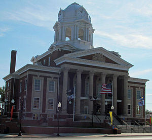
 Muhlenberg County Courthouse in Greenville | |
 Location within the U.S. state of Kentucky | |
 Kentucky's location within the U.S. | |
| Coordinates: 37°13′N 87°09′W / 37.21°N 87.15°W | |
| Country | |
| State | |
| Founded | 1798 |
| Named for | Peter Muhlenberg |
| Seat | Greenville |
| Largest city | Central City |
| Government | |
| • Judge/Executive | William "Mack" McGehee |
| Area | |
| • Total | 479 sq mi (1,240 km2) |
| • Land | 467 sq mi (1,210 km2) |
| • Water | 12 sq mi (30 km2) 2.6% |
| Population (2020) | |
| • Total | 30,928 |
| • Estimate (2023) | 30,568 |
| • Density | 65/sq mi (25/km2) |
| Time zone | UTC−6 (Central) |
| • Summer (DST) | UTC−5 (CDT) |
| Congressional district | 2nd |
| Website | www |
Muhlenberg County (/ˈmjuːlənbɜːrɡ/) is a county in the U.S. Commonwealth of Kentucky. As of the 2020 census, the population was 30,928.[1] Its county seat is Greenville and its largest city is Central City.[2]
- ^ "State & County QuickFacts". United States Census Bureau. Retrieved July 13, 2022.
- ^ "Find a County". National Association of Counties. Archived from the original on May 31, 2011. Retrieved June 7, 2011.