Mui Wo
梅窩 | |
|---|---|
Town | |
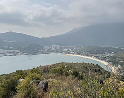
 Mui Wo, as viewed from the hills from the north in 2021 | |
 | |
| Coordinates: 22°15′52″N 114°00′5″E / 22.26444°N 114.00139°E | |
| District Council | Islands District |
| Government | |
| • Member of the District Council | Randy Yu Hon-kwan (Independent) |
| Population (2011) | |
| • Total | 5,485 |
This article has multiple issues. Please help improve it or discuss these issues on the talk page. (Learn how and when to remove these messages)
|
| Mui Wo | |||||||||||||
|---|---|---|---|---|---|---|---|---|---|---|---|---|---|
| Traditional Chinese | 梅窩 | ||||||||||||
| Simplified Chinese | 梅窝 | ||||||||||||
| Literal meaning | plum nest | ||||||||||||
| |||||||||||||
Mui Wo is a rural town on the eastern coast of Lantau Island in Hong Kong. The 2011 Census recorded 5,485 people living in Mui Wo and its environs.[1]
Mui Wo (English: Mui Wo), formerly known as Mei Wo or Mei Wei (Cantonese: Wo and Wei are homophones), is located in the eastern part of Lantau Island in the New Territories of Hong Kong. Mui Wo has a beautiful environment and is a good place for vacationing in Hong Kong.
As early as the 16th century during the Ming Dynasty, farmers were already living in Mui Wo Valley. By the 19th century, it had developed into six villages. Mui Wo is located on Silvermine Bay, so named for the silver mines that were once worked along the Silver River (銀河) which flows through the village. The main beach in Mui Wo is known as Silver Mine Bay Beach (銀鑛灣泳灘). The town is known for the feral water buffalos and cows that roam the area.[2][3]
Prior to the Airport Core Programme and the subsequent development of Tung Chung and North Lantau into a new town, Mui Wo was the principal point for day-trippers setting out to explore Lantau Island. Today, it is still the principal way of reaching South Lantau – from the beaches in Cheung Sha to the fishing village of Tai O and the Tian Tan Buddha. With the opening of Ngong Ping 360 and the new, smoother Tung Chung Road, this may change.
- ^ 2011 Population Census – Fact Sheet for Tertiary Planning Units 961 – 962, http://www.census2011.gov.hk/en/district-profiles/tpu/tpu961.html Accessed 24 June 2013. NB The census takers combine statistics for Mui Wo (Tertiary Planning Unit 962) with the sparsely populated area to the north and northwest (TPU 961) that includes Tai Ho
- ^ https://www.facebook.com/LantauBuffaloAssociation/info [user-generated source]
- ^ "CNN Travel | Global Destinations, Tips & Video".