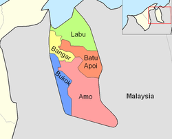
Mukim Bangar | |
|---|---|
|
Clockwise from top left: Bangar Town, Temburong District Office, Jalan Labu, Kampong Semamang | |
 Bangar is in yellow. | |
| Coordinates: 4°42′30″N 115°4′25″E / 4.70833°N 115.07361°E | |
| Country | Brunei |
| District | Temburong |
| Government | |
| • Penghulu | Sulaiman Nasir[1] |
| Area | |
• Total | 113 km2 (44 sq mi) |
| Population (2021)[3] | |
• Total | 2,112 |
| • Density | 19/km2 (48/sq mi) |
| Time zone | UTC+8 (BNT) |
| Postcode | PAxx51 |
Mukim Bangar (BAHNG-gahr)[4] is a mukim in Temburong District, Brunei. It has a total area of 113 square kilometres (44 sq mi);[2] the population was 2,112 in 2021.[5] The mukim encompasses Bangar, the district's sole town and administrative centre.
- ^ Cite error: The named reference
:3was invoked but never defined (see the help page). - ^ a b "Jabatan Daerah Temburong, Kementerian Hal Ehwal Dalam Negeri - MUKIM BANGAR". temburong.gov.bn (in Malay). Retrieved 9 January 2018.
- ^ Cite error: The named reference
Annex-B2was invoked but never defined (see the help page). - ^ Cohen, Saul Bernard (2008). The Columbia Gazetteer of the World: A to G. Columbia University Press. p. 301. ISBN 978-0-231-14554-1.
- ^ Department of Economic Planning & Statistics (October 2021). "ANNEX B" (PDF). deps.mofe.gov.bn. Retrieved 23 January 2024.


