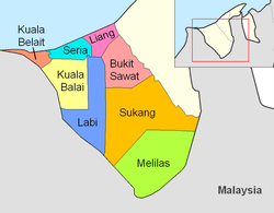
Mukim Kuala Balai | |
|---|---|
 Kampong Kuala Balai in 1964 | |
 Kuala Balai is in yellow. | |
| Country | Brunei |
| District | Belait |
| Population (2021)[1] | |
• Total | 16 |
| Time zone | UTC+8 (BNT) |
| Postcode | KDxx32 |
Mukim Kuala Balai is a mukim located in the Belait District of Brunei,[2] known for its unique geographical setting.[3] As of 2016, the population was recorded at just 31 residents.[4] The village of Kampong Kuala Balai is situated in the upper Kumgang region of Belait, forming part of the Mukim Kuala Balai catchment area. It is located approximately 28 kilometres (17 mi) from Kuala Belait. However, Kampong Kuala Balai is currently uninhabited due to factors such as migration to other villages and employment opportunities elsewhere, leading to a decline in its once-thriving community.[3] It is an early settlement of the Belait people, who formed the majority of its population, and it once served as the administrative center for the Belait District during traditional governance and British residency, while also being a prominent exporter of ambulong (sago) in its heyday.[5]
- ^ Cite error: The named reference
Annex-B2was invoked but never defined (see the help page). - ^ "Belait District" (PDF). www.information.gov.bn. 2011. pp. 8–9. Retrieved 28 June 2021.
- ^ a b Haji Su'ut Ahmad 2018, p. 13.
- ^ "Population and Housing Census Update Final Report 2016" (PDF). www.deps.gov.bn. Statistics Department. December 2018. Retrieved 27 June 2021.
- ^ Haji Su'ut Ahmad 2018, p. 17.