| Mula | |
|---|---|
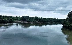
 Mula River as viewed from Harris Bridge | |
 | |
| Location | |
| Country | India |
| State | Maharashtra |
| Region | Deccan Plateau |
| District | Pune |
| Cities | Pimpri-Chinchwad, Pune |
| Physical characteristics | |
| Source | Devghar taluka |
| • location | Near Aamby Valley, Pune District, Sahyadri, Maharashtra |
| Mouth | |
• location | Sangamwadi, Pune District, Pune city, Maharashtra, India |
| Basin features | |
| Tributaries | |
| • left | Nila River, Pavana River |
| • right | Devnadi, Ramnadi, Mutha River |
The Mula is a river in Pune, in Maharashtra state of India. It is dammed near the Western Ghats at the Mulshi Dam that forms the Mulshi Lake.[1] Further downstream, in Pune city, it merges with the Pawana River on the left bank and Mutha River on the right bank to form the Mula-Mutha river, which later meets the Bhima River.[2]
The river forms the boundary between the limits of the Pimpri-Chinchwad Municipal Corporation and the Pune Municipal Corporation.The Mula flows through the center of Pune city.[3]
- ^ "Quick getaway: Mulshi dam, Chail". The Economic Times (India). 12 April 2012. Archived from the original on 6 May 2013. Retrieved 7 July 2014.
- ^ "RIVER SYSTEMS". GAZETTEERS OF BOMBAY STATE – POONA. Ministry of Culture and Tourism, Government of Maharashtra. Retrieved 7 July 2014.
- ^ "Another bridge across Mula river in Dapodi planned". Pune. Times of India. 30 July 2013. Retrieved 7 July 2014.