| Mullach nan Coirean | |
|---|---|
| Sgùrr a' Chaorainn | |
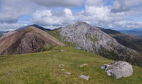
 Mullach nan Coirean seen from Stob Bàn | |
| Highest point | |
| Elevation | 939 m (3,081 ft)[1] |
| Prominence | 93 m (305 ft)[2] |
| Parent peak | Stob Bàn |
| Listing | Munro |
| Coordinates | 56°45′00″N 5°04′21″W / 56.749867°N 5.072397°W |
| Naming | |
| Language of name | Scottish Gaelic |
| Pronunciation | Scottish Gaelic: [ˈmul̪ˠəx nəŋ ˈkʰɔɾʲən] English approximation: MOO-ləkh-nən-KOR-yən |
| Geography | |
 | |
| Location | Highland, Scotland |
| Parent range | Mamores |
| OS grid | NN122662 |
| Topo map | OS Landranger 41, OS Explorers 392 |

Mullach nan Coirean (Scottish Gaelic for 'summit of the corries')[3][4] or Sgùrr a' Chaorainn ('peak of the rowan')[5] is one of the Mamores mountains in the Scottish Highlands. It reaches a height of 939 metres (3081 feet) and is the most westerly of the ten Munros in the Mamores. It has a lower peak to the west, Meall a' Chaorainn (910 m). To the east, it is linked to the neighbouring mountain Stob Bàn by a bealach at a height of 846 metres; these two Munros are often climbed together from Glen Nevis.[6]
- ^ "walkhighlands Mullach nan Coirean". walkhighlands.co.uk. 2013. Retrieved 25 November 2013.
- ^ Database of British and Irish Hills. Retrieved 21 Jan 2012.
- ^ "The Munros" Page 69 (Gives Gaelic translation as "Summit of the Corries") .
- ^ "The High Mountains of Britain and Ireland" Pages 88 (Gives Gaelic translation as "Top of the Corries").
- ^ "Mullach nan Coirean". Ainmean-Àite na h-Alba: Gaelic Place-Names of Scotland.
- ^ Munro Magic. Gives basic combined walk details from Achriabhach.