Mullan, Idaho | |
|---|---|
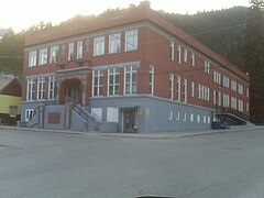
 The historic Morning Club building (1921) in 2009 | |
 Location of Mullan in Shoshone County, Idaho. | |
| Coordinates: 47°28′10″N 115°47′53″W / 47.46944°N 115.79806°W | |
| Country | United States |
| State | Idaho |
| County | Shoshone |
| Government | |
| • Mayor | Don Kotschevar |
| Area | |
| • Total | 0.83 sq mi (2.14 km2) |
| • Land | 0.83 sq mi (2.14 km2) |
| • Water | 0.00 sq mi (0.00 km2) |
| Elevation | 3,278 ft (999 m) |
| Population | |
| • Total | 692 |
| • Estimate (2019)[3] | 692 |
| • Density | 836.76/sq mi (322.92/km2) |
| Time zone | UTC-8 (Pacific (PST)) |
| • Summer (DST) | UTC-7 (PDT) |
| ZIP code | 83846 |
| Area code(s) | 208, 986 |
| FIPS code | 16-55630 |
| GNIS feature ID | 0387396 |
Mullan is a city in the northwest United States, located in the Silver Valley mining district of northern Idaho. The population was 646 at the 2020 census and 692 at the 2010 census, and 840 in 2000.
In Shoshone County at the east end of the Silver Valley,[4] Mullan is in a sheltered canyon of the Coeur d'Alene Mountains at an elevation of 3,278 feet (1,000 m) above sea level. The entrance to the Lucky Friday mine is several hundred yards east of the city center;[5] the active mine (silver, lead, & zinc) descends more than six thousand feet (1.1 mi; 1.8 km) below the surface.
Interstate 90 runs by the city's south side, and the Montana border at Lookout Pass is six miles (10 km) east at 4,700 feet (1,435 m) above sea level.
- ^ "2019 U.S. Gazetteer Files". United States Census Bureau. Retrieved July 9, 2020.
- ^ Cite error: The named reference
wwwcensusgovwas invoked but never defined (see the help page). - ^ Cite error: The named reference
USCensusEst2019CenPopScriptOnlyDirtyFixDoNotUsewas invoked but never defined (see the help page). - ^ Stack, J.L. (October 21, 1920). "Silver mines of Mullan and vicinity are grinding out ore at fast rate". Spokane Daily Chronicle. p. 26.
- ^ MSR Maps - USGS topo map - Mullan, Idaho - accessed 2011-12-11