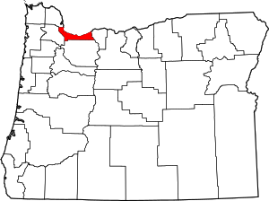
Multnomah County | |
|---|---|
 Location within the U.S. state of Oregon | |
 Oregon's location within the U.S. | |
| Coordinates: 45°32′N 122°25′W / 45.54°N 122.41°W | |
| Country | |
| State | |
| Founded | December 22, 1854 |
| Named for | Multnomah people |
| Seat | Portland |
| Largest city | Portland |
| Area | |
• Total | 466 sq mi (1,210 km2) |
| • Land | 431 sq mi (1,120 km2) |
| • Water | 34 sq mi (90 km2) 7.4% |
| Population (2020) | |
• Total | 815,428 |
• Estimate (2023) | 789,698 |
| • Density | 1,700/sq mi (680/km2) |
| Time zone | UTC−8 (Pacific) |
| • Summer (DST) | UTC−7 (PDT) |
| Congressional districts | 1st, 3rd, 5th |
| Website | www |
Multnomah County /mʌltˈnoʊmə/ is one of the 36 counties in the U.S. state of Oregon. As of the 2020 census, the county's population was 815,428.[1] Multnomah County is part of the Portland–Vancouver–Hillsboro, OR–WA metropolitan statistical area. The state's smallest and most populous county,[2] its county seat, Portland, is the state's largest city.[3]

- ^ "State & County QuickFacts". United States Census Bureau. Retrieved March 20, 2024.
- ^ "Oregon Almanac: Abbreviation to Counties". Oregon Blue Book. State of Oregon. Archived from the original on October 25, 2018. Retrieved July 4, 2007.
- ^ "Find a County". National Association of Counties. Retrieved June 7, 2011.[dead link]


