| Mundijong Perth, Western Australia | |||||||||||||||
|---|---|---|---|---|---|---|---|---|---|---|---|---|---|---|---|
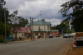
 Paterson Street, Mundijong | |||||||||||||||
 | |||||||||||||||
| Coordinates | 32°17′02″S 115°58′23″E / 32.284°S 115.973°E | ||||||||||||||
| Population | 1,246 (SAL 2021)[1] | ||||||||||||||
| Established | 1890s | ||||||||||||||
| Postcode(s) | 6123 | ||||||||||||||
| Area | 18.4 km2 (7.1 sq mi)[2] | ||||||||||||||
| Location | |||||||||||||||
| LGA(s) | Shire of Serpentine-Jarrahdale | ||||||||||||||
| State electorate(s) | Darling Range | ||||||||||||||
| Federal division(s) | Canning | ||||||||||||||
| |||||||||||||||
Mundijong is an outer suburb of the Western Australian capital city of Perth.
Originally named Jarrahdale Junction, it was at the junction of the Jarrahdale to Rockingham railway line and the government railway line from Perth to Bunbury, which was built in 1893.
At the 2016 census, Mundijong had a population of 1,232.[3]
A town grew up around the junction, and a timber depot, which included a large planing mill, was constructed. The town was first declared as "Manjedal" in 1893 as it was thought to be the Aboriginal name of the area. In 1897 this was found to be incorrect, and the name was changed to Mundijong. It was officially gazetted as a locality on 1 May 1997.[4]
- ^ Australian Bureau of Statistics (28 June 2022). "Mundijong (suburb and locality)". Australian Census 2021 QuickStats. Retrieved 28 June 2022.
- ^ Australian Bureau of Statistics (27 June 2017). "2016 Community Profiles: Mundijong (State Suburb)". 2016 Census of Population and Housing. Retrieved 29 October 2019.
- ^ Australian Bureau of Statistics (27 June 2017). "Mundijong (State Suburb)". 2016 Census QuickStats. Retrieved 5 June 2018.
- ^ "History of metropolitan suburb names – M". Western Australian Land Information Authority. Archived from the original on 16 March 2022. Retrieved 12 October 2019.