| Mundrabilla Western Australia | |||||||||
|---|---|---|---|---|---|---|---|---|---|
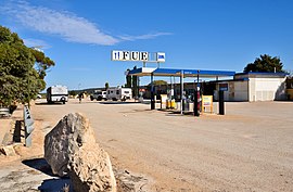
 Mundrabilla Roadhouse, 2017 | |||||||||
 | |||||||||
| Coordinates | 31°49′3.70″S 128°13′31.19″E / 31.8176944°S 128.2253306°E | ||||||||
| Population | 11 (SAL 2021)[1] | ||||||||
| Established | 1872 | ||||||||
| Postcode(s) | 6443 | ||||||||
| Elevation | 20 m (66 ft) | ||||||||
| Area | 6,292 km2 (2,429 sq mi) | ||||||||
| Location | |||||||||
| LGA(s) | Shire of Dundas | ||||||||
| State electorate(s) | Eyre | ||||||||
| Federal division(s) | O'Connor | ||||||||
| |||||||||
Mundrabilla is in a very sparsely populated area in the far south east of Western Australia. The two significant features are Mundrabilla Roadhouse and Mundrabilla Station, which are approximately 35 kilometres (22 mi) apart. At the 2016 census, Mundrabilla had a population of 23, 32% male and 68% female.[2] The time zone in use is UTC+08:45.[3]
- ^ Australian Bureau of Statistics (28 June 2022). "Mundrabilla (suburb and locality)". Australian Census 2021 QuickStats. Retrieved 28 June 2022.
- ^ Australian Bureau of Statistics (27 June 2017). "Mundrabilla (State Suburb)". 2016 Census QuickStats. Retrieved 20 June 2018.
- ^ "Australia's Weird Little Time Zone". 12 July 2008.
