Munnar | |
|---|---|
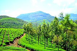
 A view of Munnar | |
| Nickname: The Kashmir of South India | |
| Coordinates: 10°05′21″N 77°03′35″E / 10.08917°N 77.05972°E | |
| Country | India |
| State | Kerala |
| District | Idukki |
| Taluk | Devikulam |
| Named for | Tea plantations, cool climate |
| Government | |
| • Type | Grama Panchayat |
| • Body | Munnar grama panchayath |
| Area | |
• Total | 187 km2 (72 sq mi) |
| Elevation | 1,532 m (5,026 ft) |
| Population (2011) | |
• Total | 32,029 |
| • Density | 170/km2 (440/sq mi) |
| Languages | |
| • Official | Malayalam[2] |
| • Regional | Tamil,[3] Malayalam |
| Time zone | UTC+5:30 (IST) |
| PIN | 685612 |
| Telephone code | 04865 |
| Vehicle registration | KL-68, KL-06 |
| Literacy | 84.9% |
| Website | keralatourism |
Munnar (IPA: [muːn̪ːɐːr]) is a town and hill station located in the Idukki district of the southwestern Indian state of Kerala. Munnar is situated at around 1,600 metres (5,200 ft) above mean sea level,[4] in the Western Ghats mountain range. Munnar is also called the "Kashmir of South India" and is a popular honeymoon destination.
- ^ Munnar - Fallingrain
- ^ "The Kerala Official Language (Legislation) Act, 1969" (PDF).
- ^ "Table C-16 Population by Mother Tongue: Kerala". www.censusindia.gov.in. Registrar General and Census Commissioner of India.
- ^ "Munnar - the Hill Station of Kerala in Idukki | Kerala Tourism". Archived from the original on 18 January 2014. Retrieved 21 June 2012.

