Munshiganj
মুন্সীগঞ্জ | |
|---|---|
Clockwise from top-left: Idrakpur Fort, Baba Adam's Mosque, Meghna near Munshiganj, Sonarong Jor Moth, Dhaleshwari River bank in Munshiganj Sadar Upazila, Nateshwar Deul, Padma Bridge | |
| Nickname: | |
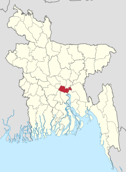
 Location of Munshiganj District in Bangladesh | |
 Expandable map of Munshiganj District | |
| Coordinates: 23°28′N 90°32′E / 23.46°N 90.54°E | |
| Country | |
| Division | Dhaka |
| Headquarters | Munshiganj |
| Government | |
| • Deputy Commissioner | Kazi Nahid Rasul [1] |
| Area | |
| • Total | 954.96 km2 (368.71 sq mi) |
| Population | |
| • Total | 1,625,416 |
| • Density | 1,700/km2 (4,400/sq mi) |
| Demonym(s) | Munshiganji, Bikrompuira, Bikrampuri, Dhakaiya |
| Time zone | UTC+06:00 (BST) |
| Postal code | 1500 |
| Area code | 0691 |
| ISO 3166 code | BD-35 |
| HDI (2018) | 0.649[4] medium · 3rd of 21 |
Munshiganj (Bengali: মুন্সীগঞ্জ), also historically and colloquially known as Bikrampur, is a district[5] in central Bangladesh. It is a part of the Dhaka Division and borders Dhaka District.[6]
- ^ "List of Deputy Commissioners".
- ^ Population and Housing Census 2022 - District Report: Munshiganj (PDF). District Series. Dhaka: Bangladesh Bureau of Statistics. June 2024. ISBN 978-984-475-282-5.
- ^ Cite error: The named reference
2022censuswas invoked but never defined (see the help page). - ^ "Sub-national HDI - Area Database - Global Data Lab". hdi.globaldatalab.org. Retrieved 2020-03-18.
- ^ "Bangladesh Government 1995 - Flags, Maps, Economy, Geography, Climate, Natural Resources, Current Issues, International Agreements, Population, Social Statistics, Political System". theodora.com. Retrieved 2015-06-22.
- ^ Ratantanu Ghosh (2012). "Munshiganj District". In Sirajul Islam; Ahmed A. Jamal (eds.). Banglapedia: National Encyclopedia of Bangladesh (Second ed.). Asiatic Society of Bangladesh.


