| Mutasarrifate of Jerusalem Kudüs-i Şerif Mutasarrıflığı | |||||||||
|---|---|---|---|---|---|---|---|---|---|
| Mutasarrifate of the Ottoman Empire | |||||||||
| 1872–1917 | |||||||||
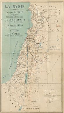
 Vital Cuinet's 1896 map of Syria, including the "Mutessariflik de Jerusalem" | |||||||||
| Capital | Jerusalem | ||||||||
| Area | |||||||||
• 1862[2] | 12,486 km2 (4,821 sq mi) | ||||||||
| Population | |||||||||
• 1897[1] | 298,653 | ||||||||
| History | |||||||||
• Established | 1872 | ||||||||
| 1917 | |||||||||
| |||||||||
| Today part of | Egypt Israel Jordan Palestine | ||||||||
The Mutasarrifate of Jerusalem (Ottoman Turkish: قُدس شَرِيف مُتَصَرِّفلغى, Kudüs-i Şerif Mutasarrıflığı; Arabic: متصرفية القدس الشريف, Mutaṣarrifiyyat al-quds aš-šarīf, French: Moutassarifat de Jérusalem), also known as the Sanjak of Jerusalem, was an Ottoman district with special administrative status established in 1872.[3][4][5] The district encompassed Jerusalem as well as Hebron, Jaffa, Gaza and Beersheba.[6] During the late Ottoman period, the Mutasarrifate of Jerusalem was commonly referred to as Palestine;[3] a very late Ottoman document describes Palestine as including the Sanjak of Nablus and Sanjak of Akka (Acre) as well, more in line with European usage.[nb 1] It was the 7th most heavily populated region of the Ottoman Empire's 36 provinces.[7]
The district was separated from the Damascus Eyalet and placed directly under the supervision of the Ottoman central government in Constantinople (now Istanbul) in 1841, and formally created as an independent province in 1872 by Grand Vizier Mahmud Nedim Pasha.[8] Scholars provide a variety of reasons for the separation, including increased European interest in the region, and strengthening of the southern border of the Empire against the Khedivate of Egypt.[8][4] Initially, the Mutasarrifate of Acre and Mutasarrifate of Nablus were combined with the province of Jerusalem, with the combined province being referred to in the register of the court of Jerusalem as the "Jerusalem Eyalet", and referred to by the British consul as the creation of "Palestine into a separate eyalet".[4] After less than two months,[4] the sanjaks of Nablus and Acre were separated and added to the Vilayet of Beirut, leaving just the Mutasarrifate of Jerusalem.[9] In 1906, the Kaza of Nazareth was added to the Jerusalem Mutasarrifate as an exclave,[10] primarily in order to allow the issuance of a single tourist permit to Christian travellers.[11] The area was conquered by the Allied Forces in 1917 during World War I[12] and a military Occupied Enemy Territory Administration, OETA South, was set up to replace the Ottoman administration.[13] OETA South consisted of the Ottoman sanjaks of Jerusalem, Nablus and Acre. The military administration was replaced by a British civilian administration in 1920 and the area of OETA South was incorporated into the British Mandate of Palestine in 1923.
The political status of the Mutasarrifate of Jerusalem was unique from other Ottoman provinces as it was under the direct authority of the Ottoman government in Constantinople.[5] The inhabitants identified themselves primarily on religious terms, 84% being Muslim Arabs.[14] The district's villages were normally inhabited by farmers while its towns were populated by merchants, artisans, landowners and money-lenders. The elite consisted of the religious leadership, wealthy landlords and high-ranking civil servants.[14]
- ^ Mutlu (2003). Corrected population for Mortality Level=8.
- ^ The Popular Encyclopedia (1862).
- ^ a b Büssow (2011), p. 5.
- ^ a b c d Abu-Manneh (1999), p. 39.
- ^ a b Jankowski & Gershoni (1997), p. 174.
- ^ Beshara (2012), pp. 23.
- ^ Karpat (1985), p. 210.
- ^ a b Abu-Manneh (1999), p. 38.
- ^ Büssow (2011), pp. 41–44.
- ^ Kark (1994), p. 131.
- ^ Büssow (2011), p. 70.
- ^ Powles & Wilkie (1922), pp.167-168.
- ^ Macmunn & Falls, p. 607.
- ^ a b El-Hasan (2010), p. 38.
Cite error: There are <ref group=nb> tags on this page, but the references will not show without a {{reflist|group=nb}} template (see the help page).
