Myitkyina
မြစ်ကြီးနားမြိူ့ Myitkyina Muklum | |
|---|---|
Capital Town | |
 | |
| Coordinates: 25°23′0″N 97°24′0″E / 25.38333°N 97.40000°E | |
| Country | |
| Division | |
| District | Myitkyina District |
| Township | Myitkyina Township |
| Elevation | 472 ft (144 m) |
| Population (2014) | |
| • Urban | 210,949 |
| • Ethnicities | |
| • Religions | |
| Time zone | UTC+6.30 (MMT) |
| Area code | 74 |
| Climate | Am/Aw/Cwa |
| [1] | |
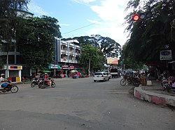
Myitkyina (Burmese: မြစ်ကြီးနားမြို့; MLCTS: mrac kri: na: mrui., pronounced [mjɪʔtɕíná]; (Eng; mitchinar) Jinghpaw: Myitkyina, [mjìtkjí̠ná]) is the capital city of Kachin State in Myanmar (Burma), located 1,480 kilometers (920 mi) from Yangon, and 785 kilometers (488 mi) from Mandalay [1]. In Burmese it means "near the big river", and Myitkyina is on the west bank of the Ayeyarwady River, just below 40 kilometers (25 mi) from Myit-son (Burmese for confluence) of its two headstreams (the Mali and N'mai rivers).[2] It is the northernmost river port and railway terminus in Myanmar.[3] The city is served by Myitkyina Airport.
- ^ "National Telephone Area Codes". Myanmar Yellow Pages. Archived from the original on 2009-07-19.
- ^ "Myitkyina, Myanmar". Encyclopædia Britannica Online. Retrieved 2009-03-29.
- ^ "Train travel in Myanmar (Burma)". seat61.com. Retrieved 2009-03-29.
