| National route N10 | ||||
|---|---|---|---|---|
 | ||||
 The N10 in the Northern Cape | ||||
| Route information | ||||
| Maintained by SANRAL | ||||
| Length | 1,000 km (620 mi) | |||
| Major junctions | ||||
| Northwest end | ||||
| Southeast end | ||||
| Location | ||||
| Country | South Africa | |||
| Provinces | Northern Cape, Eastern Cape | |||
| Major cities | ||||
| Highway system | ||||
| ||||
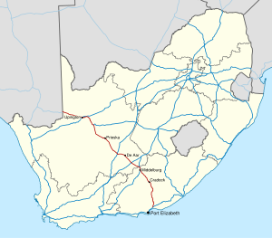
The N10 is a national route in South Africa connecting Gqeberha on the Eastern Cape coast with the Namibian border at Nakop, via Cradock, De Aar and Upington.[1]
- ^ Falkner, John (May 2012). South African Numbered Route Description and Destination Analysis (Report). National Department of Transport. p. 24. Archived from the original on 6 June 2014. Retrieved 12 August 2014.
