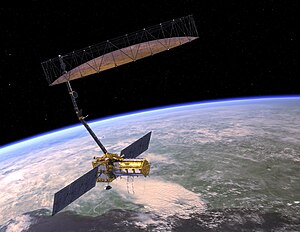
 Artist's concept of the NASA-ISRO Synthetic Aperture Radar (NISAR) satellite. | |
| Names | NASA-ISRO Synthetic Aperture Radar NISAR |
|---|---|
| Mission type | Radar imaging |
| Operator | NASA / ISRO |
| Website | nisar www |
| Mission duration | 3 years (planned)[1][2] |
| Spacecraft properties | |
| Spacecraft | NISAR |
| Bus | I-3K[3] |
| Manufacturer | NASA / ISRO |
| Launch mass | 2,800 kg (6,200 lb)[4] |
| Power | 6,500 watts |
| Start of mission | |
| Launch date | Q1 2025 (planned)[5] |
| Rocket | GSLV Mk II (4 meter fairing)[3] |
| Launch site | Satish Dhawan Space Centre |
| Contractor | ISRO |
| Orbital parameters | |
| Reference system | Geocentric orbit[1] |
| Regime | Sun-synchronous orbit[6] |
| Altitude | 747 km (464 mi) |
| Perigee altitude | 747 km (464 mi) |
| Apogee altitude | 747 km (464 mi) |
| Inclination | 98.5° |
| Transponders | |
| Band | S-band L-band |
| Instruments | |
| L-band (24-cm wavelength) Polarimetric Synthetic Aperture Radar S-band (12-cm wavelength) Polarimetric Synthetic Aperture Radar | |
 NISAR mission logo | |
The NASA-ISRO Synthetic Aperture Radar (NISAR) mission is a joint project between NASA and ISRO to co-develop and launch a dual-frequency synthetic aperture radar on an Earth observation satellite in 2025. The satellite will be the first radar imaging satellite to use dual frequencies. It will be used for remote sensing, to observe and understand natural processes on Earth. For example, its left-facing instruments will study the Antarctic cryosphere.[7] With a total cost estimated at US$1.5 billion, NISAR is likely to be the world's most expensive Earth-imaging satellite.[8]
- ^ a b "Satellite: NISAR". World Meteorological Organization (WMO). 4 January 2020. Retrieved 16 March 2021.
- ^ "Optimization of Debris Shields on the NISAR Mission's L-Band Radar Instrument" (PDF). conference.sdo.esoc.esa.int. ESA Space Debris Office. 18–21 April 2017. Retrieved 16 March 2021.
- ^ a b "Overview of NISAR Mission and Airborne L- and S- SAR" (PDF). sac.gov.in. Space Applications Centre, ISRO. August 2018. Retrieved 16 March 2021.
- ^ Neeck, Steven. "The NASA Earth Science Program and Small Satellites" (PDF). dlr.de. DLR. Archived from the original (PDF) on 23 November 2018. Retrieved 23 November 2018.
- ^ "Amendment 33: A.27 NISAR Research and Applications Science Team Deferred to ROSES-25". Science Mission Directorate. 18 July 2024. Retrieved 28 July 2024.
- ^ "NISAR Mission". ISRO. 19–20 November 2015. Archived from the original on 4 August 2020. Retrieved 16 March 2021.
- ^ Witze, Alexandra (4 February 2019). "Arctic scientists iced out by U.S.–India radar mission". Nature. 566 (7742): 18. Bibcode:2019Natur.566...18W. doi:10.1038/d41586-019-00278-8. PMID 30723349.
- ^ "NASA, ISRO jointly working on project NISAR". NASA/JPL (Press release). SAR Journal. 26 May 2017. Retrieved 16 March 2021.