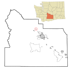
Naches | |
|---|---|
| Naches, Washington | |
 Town hall | |
 Location of Naches, Washington | |
| Coordinates: 46°43′45″N 120°41′57″W / 46.72917°N 120.69917°W | |
| Country | United States |
| State | Washington |
| County | Yakima |
| Founded | 1909 |
| Government | |
| • Mayor | Bill Davis[1] |
| Area | |
| • Total | 0.87 sq mi (2.26 km2) |
| • Land | 0.87 sq mi (2.26 km2) |
| • Water | 0.00 sq mi (0.00 km2) |
| Elevation | 1,473 ft (449 m) |
| Population | |
| • Total | 1,084 |
| • Estimate (2021)[4] | 1,046 |
| • Density | 971.33/sq mi (375.17/km2) |
| Time zone | UTC-8 (PST) |
| • Summer (DST) | UTC-7 (PDT) |
| ZIP codes | 98929, 98937 |
| Area code | 509 |
| FIPS code | 53-47805[5] |
| GNIS feature ID | 1512494[6] |
| Website | townofnaches.com |
Naches is a town in Yakima County, Washington, United States. The population was 1,084 at the 2020 census.[3] The town is located along the Naches River west of Yakima near the eastern foothills of the Cascade Range.
- ^ "Mayor & Town Council". Town of Naches. Retrieved June 24, 2024.
- ^ "2019 U.S. Gazetteer Files". United States Census Bureau. Retrieved August 7, 2020.
- ^ a b "Explore Census Data". United States Census Bureau. Retrieved September 13, 2022.
- ^ Cite error: The named reference
USCensusEst2021was invoked but never defined (see the help page). - ^ "U.S. Census website". United States Census Bureau. Retrieved January 31, 2008.
- ^ "US Board on Geographic Names". United States Geological Survey. October 25, 2007. Retrieved January 31, 2008.