This article needs additional citations for verification. (April 2017) |
Nadur
In-Nadur | |
|---|---|
 View from the Nadur Square showing the Church of the Sacred Heart of Jesus (a smaller church close to the Nadur Parish Church) | |
 | |
| Coordinates: 36°2′17″N 14°17′42″E / 36.03806°N 14.29500°E | |
| Country | |
| Region | |
| District | Gozo and Comino District |
| Established | 1932 |
| Borders | Għajnsielem, Qala, Xagħra |
| Government | |
| • Mayor | Edward Said (PN) |
| Area | |
• Total | 7.2 km2 (2.8 sq mi) |
| Population (March 2014) | |
• Total | 4,509 |
| • Density | 630/km2 (1,600/sq mi) |
| Demonym(s) | Naduri (m), Nadurija (f), Nadurin (pl) |
| Time zone | UTC+1 (CET) |
| • Summer (DST) | UTC+2 (CEST) |
| Postal code | NDR |
| Dialing code | 356 |
| ISO 3166 code | MT-37 |
| Patron saint | St. Peter and St. Paul |
| Day of festa | 29 June |
| Website | Official website |
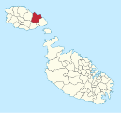
Nadur (Maltese: In-Nadur) is an administrative unit of Malta, located in the eastern part of the island of Gozo. Nadur is built on a plateau and is one of the largest localities in Gozo.[1] Known as the 'second city', it spreads along a high ridge to the east of Victoria. It had a population of 4,509 as of March 2014.[2]
The word is derived from the Arabic word ‘nadara’, which means 'lookout', pretty much having the same meaning as its motto ‘Vigilant’.[1] The motto appears in Nadur’s coat of arms that shows the sun coming up from blue seas. The town is famous for its bakeries.[3]
Near Nadur are San Blas and Dahlet Qorrot Bays, tiny rocky bays on the North Eastern coast. These are locations for swimming, snorkeling, picnics, and trekking.[1]
- ^ a b c "Nadur".
- ^ "Estimated Population by Locality 31st March, 2014". Government of Malta. 16 May 2014. Archived from the original on 21 June 2015.
- ^ "Nadur".

